


20 Béjar Hostal Extremeño

berlage
User
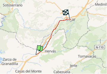

Length
26 km

Max alt
965 m

Uphill gradient
718 m
Km-Effort
34 km

Min alt
521 m

Downhill gradient
277 m
Boucle
No
Creation date :
2024-09-26 06:58:25.993
Updated on :
2024-09-26 13:56:09.187
6h55
Difficulty : Difficult

FREE GPS app for hiking
 SityTrail
IGN / Geographical institutes
SityTrail Plus
The world is yours!
About
Trail Walking of 26 km to be discovered at Extremadura, Cáceres, Aldeanueva del Camino. This trail is proposed by berlage.
Positioning
Country:
Spain
Region :
Extremadura
Department/Province :
Cáceres
Municipality :
Aldeanueva del Camino
Location:
Unknown
Start:(Dec)
Start:(UTM)
251226 ; 4460780 (30T) N.
Comments